Natural Gas
Sewall’s geospatial professionals work for natural gas companies throughout the U.S. providing a broad range of consulting services such as asset management, field data collection, remote sensing, GIS department assistance, and addressing federal regulations such as determining class locations and high consequence areas.
GIS Department Assistance
Sewall works alongside your GIS team, providing integrated support to:
- Help manage heavy workloads
- Extend your GIS capabilities
- Assist with special projects as an extension of your team
Asset Management
For over a half-century, Sewall has provided an extensive array of asset management services.
- Assess and inventory existing digital and non-digital data
- Migrate hardcopy records (maps, plans, drawings, etc.) to digital media
- Design and implement optimal database schemas
- Provide platforms for managing and collecting data in several environments, including desktop, web-based, and offline fieldwork
- Expand existing data by incorporating new data sources, new methodologies, and/or by connecting to related resources
Remote Sensing
For over 75 years, Sewall has provided clients with high-quality aerial imagery and photogrammetric mapping. Sewall’s services include:
- Remote Sensing Acquisition – Capture of aerial imagery and LiDAR throughout the US and Canadian Maritimes
- Photogrammetric Mapping – Automated and manual collection of accurate planimetric and topographic/contour data
- Remote Sensing Products & Services – Digital orthoimagery, digital terrain models, digital elevation models, digital surface models, change detection
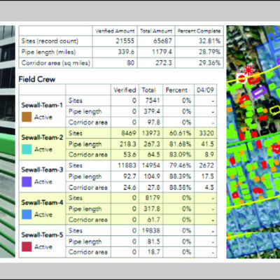
Field Data Collection
Sewall’s Mobile Verify™ platform supports field data collection and verification efforts. Configured to conduct offline field surveys of natural gas transmission pipeline corridors, Mobile Verify™ is used to collect asset information in the field. Collected data and fieldwork progress is available from Sewall’s Mobile Verify Dashboard™.
- Flexible integration with data architecture
- Offline data collection capabilities
- Web-enabled synchronization of data
- Expandable, multi-user environment
- Configurable data validation rules
- Intelligent, streamlined data forms
Class Location and High Consequence Areas (HCA)
Using its own innovative and time-tested solutions, Sewall’s geospatial professionals have decades of consulting experience in assisting gas operators in achieving pipeline integrity compliance when it comes to class location and HCA. Sewall’s ClassLocator™ and HCACalculator™ are designed based upon US Department of Transportation Pipeline Safety Regulations Part 192.5 and Part 192 Subpart O, respectively.