Wind
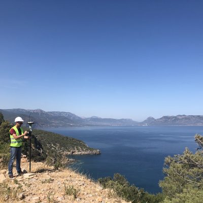
Sewall has been a key player in driving the adoption of renewable energy technologies and helped position Maine as New England’s leader in wind power. Our engineers supported the development of the first commercial wind project in Maine and the largest commercial wind farm in New England. Sewall continues to provide siting assistance, civil design, and permitting services for several current wind farm development projects in Maine, New England, and the mid-Atlantic states.
Identifying and selecting wind resource areas (WRAs) require knowledge of multiple factors, including suitable wind class resources; supportive land ownership, land use and population density; proximity to transmission lines and regional customers; and critical community support. Sewall understands the need to balance these factors and to bring together the interests of engineering and energy firms, landowners, environmental groups, and the public. We provide a full range of project life-cycle services, including:
- Parcel and land ownership mapping
- Aerial photography, GPS surveying, mapping, and digital orthophotography
- Environmental, cultural/historical, road, and hydrographic data compilation
- Site fatal flaw analyses
- Assistance in acquiring leases, easements, and ROWs
- Access road and turbine site design and permitting
- Stakeholder meeting facilitation
- Asset management and maintenance using GIS technology
Sewall has developed a web-based GIS application and data-sharing platform to support our existing wind energy clients. This platform has the power to meet the continuing needs of all stakeholders, providing access to:
- Tax parcel mapping with land ownership attributes
- Site topographic mapping and digital orthophotography
- Planimetric features (roads, bodies of water, historic sites, utility infrastructure)
- Land use and natural resource mapping (wetlands, streams, vernal pools)
- Applications for asset monitoring, reporting, and maintenance